Showing posts with label trip report. Show all posts

Monday, April 2, 2012

Wallowas! (aka, Winter's Last Gasp)

I'm back on the grid! After weeks of blogging and talking about it, the trip to the Wallowas happened.

Bright and early last Tuesday morning, five of us set out for a 7+ hour drive to Joseph, Oregon, from Bend. Our ultimate destination: the Wallowa Mountains. After playing in Bend for three straight days, I was my hip flexors were grateful for a travel/rest day. 
Gear and skis for 5 actually fit into a Suburban!
I'd skied the backcountry before, and I've even hauled in my skis a few times for the spring Tuckerman Ravine ritual. But the Wallowas would be my first multi-day backcountry ski trip. Until this week, I'd only done day trips, and I'd slapped skins onto my skis a grand total of probably 4 times, if you count the first day of my avalanche class where we were focused on rescue, not climbing, techniques. I'm also counting the time that I skinned up a closed ski area in New Hampshire.

I'd been feeling for a few years that backcountry skiing was the next progression for me, so I was super excited when Charlotte called in January inviting me on the trip that she and Aaron were planning. It would be a relatively flat 4-mile ski into the huts, from which we could access some amazing terrain. My hope was that even coming from sea level, I'd be able to keep up with everyone (uhm, yeah), and with any additional luck, my feet would remain relatively blister-free (I was a little more successful at this one). 

We arrived in Joseph, Oregon, just after 5pm. Our plan was to spend the night here before heading onto the trail the next morning. Not so conveniently, nearly every store in town closed at 5pm in the winter. Our only options for killing time before dinner were checking out Our Little Store and window shopping. 
The results of our not-so-blind taste tests of Mexican Pepsi
and Mexican Coke purchased at Our Little Store: Mexican
Pepsi has more flavor than Mexican Coke. Who knew?
Carb loading at Embers Brewhouse, one of the few
open establishments in Joseph after 5pm
My room at Chandlers' Inn. Pretty inspiring!
The hut company sent an employee to our B&B for a briefing Wednesday morning, and a Forest Service ranger also joined us. Then we headed out to the Sno-Park.

If you've spent your entire life on the east coast like me, you probably have never heard of a Sno-Park. Thanks to Google, I've learned (in the last five minutes) that there are Sno-Parks in Oregon, Washington, California (and probably other states), and permits are required for parking there. Yay, Google.

DAY 1
After gearing up in the parking lot, we set out. Our goal for Day 1 was to make it into camp, and depending on how we felt afterward, maybe climb for some turns.
I've never been successful at shooting non-butt
photos of people gearing up...
View from the Sno-Park parking lot.
Every now and then, the sky brightened, and we were treated 
to great views. 
Practicing some spacing. The guys are way out in front with 
the sled. We won't talk about the sled, but let's just say there's a 
reason that two people needed to maneuver one sled. Charlotte 
and Christa are also in front of me, so I was just hanging out, 
taking pix.
Snowmobile high marking tracks on the treeless slope 
near center.
We arrived at camp too late for more skiing, but Christa and Andrew had brought in fresh food (hello, sled!) and whipped up an amazing backcountry meal: fresh salmon, rice, asparagus, and...brussels sprouts. My second brussels sprouts experience ever, and it happened in the backcountry. Not kidding. They weren't bad, either.
Veggies being prepped. I was a little apprehensive about the sprouts. 
I mean what kind of wacko people pack in Brussels sprouts??
The complete meal.
DAY 2
When we woke up the next day, it was snowing and there were several inches of fresh snow on the ground! Whee! After a bit of climbing and some snow pit digging and analysis (thanks, Aaron!), we skied.
Rise and shine!
Freshies at camp!
The kitchen hut is to the left, and sauna hut to the right.
Charlotte skins up.
I've approximately two photos of the climb up because I was working hard. The reward, though, was worth it.

Here's the thing: I know this is blasphemous, but my powder skiing is marginal, and with a pack throwing my balance off, it became atrocious. Nevertheless, I managed to get comfortable with it by the end of the run. So even though this isn't me skiing down, it's a picture of my tracks, which enter the photo on the left behind some trees, cross over another set of tracks and end, well, at the bottom of the frame, where I'm taking the photo. 
My tracks (and evidence of my outriggers).

DAY 3
And on the third day, it rained. All. Day. So I played Bananagrams. A few times with Charlotte, Aaron, and Andrew, and once solo. Yep, I know how to have fun on a rainy day in a ski hut. 
The completed Bananagrams board. And honey bear.
A part of me was glad for the forced rest day. I'm not used to skiing with a pack. Between skiing in on Day 1 and the skiing on Day 2, my right calf was weirdly sore in a spot I don't think I'd ever felt it sore. I sort of felt that I needed some rest so that I'd be able to ski out the next day. But the rain was also depressing. We all hoped that it hadn't deteriorated the snow too much – like melt the snow bridges over the water crossing – for the ski out, and that the weather would improve in general.

DAY 4
I don't know about anyone else in the group, but given that it was pouring rain when we went to bed on Thursday night and raining even harder on Friday night when we hit they hay, I wasn't entirely sure it would clear up for our ski out. I woke up a few times in the night and was pleasantly surprised not to hear any drips. I did, however, hear weird rippling sounds that sounded like rodents and freaked myself out. After I finally fell asleep for good, I woke up to this:

The sun rises behind Christa & Andrew's hut. 
We cleaned up camp following the strenuous checkout requirements and then worked our way out of the backcountry. On our way out, we actually crossed paths with the group coming in for the weekend. I was mildly jealous because the weather report looked pretty good for their stay.
Strenuous checkout duties (and camp rules).
We had lucked out with amazing weather for the ski out!
Amazing views, too. Btw, does this beacon make me look fat?
The route follows the contour of the slope.
It was sunny, warm, and a little very breezy. We could spot the parking lot from a distance, and it was a little sad to realize that each stride brought me closer to the end of my 2011-2012 ski season. I had eked out all that I could. It's now time to hang up the skis and focus on running.

I'm super grateful to have had this opportunity to head out into the backcountry with such fun and patient people. I can't wait to do it again!

Thursday, August 18, 2011

The Land of Enchantment

The last time I was in New Mexico, my then-Baltimore-based AT through-hiker pal Moon Monster and I were passing through on I-40, feverishly trying to outrun a winter storm. So, it was awesome to head back this week, to the northern part of the state, where I've never spent any time. Earlier this week, I was a "volunteer role model" (heh) to over thirty minority high school juniors and seniors, and college freshmen and sophomores interested in careers related to the environment. I know I've got more than one students' dream job, but if working in places like these are part of the job description, well, a career where field work is the norm isn't too shabby, either.

Pecos National Historical Park, from the Forked Lightning Ranch House
I spent two days hanging out with the students and their awesome instructors (from the USGS and USFS) as they tested water quality and flow, and identified fauna, aquatic macro invertebrates, and birds in Pecos National Historical Park and the Santa Fe National Forest.* Seriously, who knows what I would have turned into if I did a summer program like this when I was 18, rather than sweat to death selling concessions at the premier water park of northwestern New Jersey! I'd be the next John Muir! Or a dirtbag skier.... hmmm....

Netting macro invertebrates for identification.
My fave tree: Aspens! Santa Fe National Forest

* Disclaimer:  We went to a waste water treatment plant, too, but I'll spare you the pics. Thank me later.


Thursday, July 21, 2011

Belated write-up of Washington to Washington: the Return

So, a year ago today, the Transporter and I set off for Seattle.  Unbeknownst to many, I returned to DC in February, after 8 days on the road.  I logged way more miles than I had on the drive out and absolutely fell in love with Flagstaff, even though I've now been there for a grand total of 2 days in my life.

Because the Transporter gave birth to a darling baby girl on January 11 (1/11/11 -- how cool is that??!), she wasn't available to co-pilot the return drive.  The night before I left, a Seattle pal, whom I've dubbed the Last-Minute Interloper, agreed to do the drive from Seattle to San Luis Obispo with me.  I would then pick up another friend -- Moon Monster (this is actually his trail name from when he through-hiked the Appalachian Trail in 2003) -- in San Luis Obispo, and we'd drive back east.

The Itinerary

Day 1: Seattle to Eugene (with Last-Minute Interloper and a stop for lunch in Portland)
Day 2: Eugene to San Francisco (spent a night with my bff) 
Day 3: San Francisco to Mojave (with stop in San Luis Obispo to pick up the Transporter v. 2.0, aka Moon Monster, and to drop off LMI)
Day 4: Mojave to Flagstaff
Day 5: Flagstaff to Albuquerque
Day 6: Albuquerque to Joplin, MO (to outrun the imminent snowstorm)
Day 7: Joplin, MO to Dayton, OH
Day 8: Dayton, OH to Baltimore/Washington, DC


So, here are the highlights of the return drive from Seattle to Washington, DC:
  • Most importantly, the Transporter v. 2.0 (aka, Moon Monster) and I returned to the east coast having driven in merely trace amounts of snow.  This is notable because Oklahoma City, Little Rock, and Memphis (aka, I-40) got walloped the days after we went through.  And the week before, too.
  • I-5 through Washington, Oregon and northern California is, simply, gorgeous. I really want to ski in the Marble Mountain Wilderness.  LMI and I kept ogling the potential routes.  Miraculously, I did not drive off the road.
  • It's kind of dorky, but I got a kick out of driving by the exit for Sleater-Kinney Road outside Olympia.  While I was in Seattle, I'd driven by the exit at least 5 times, and it never got old.  
  • Everyone warned me that Eugene was a vortex of weirdness, and they were right.  My night with LMI, his grade-school pal, and my high school roommate was something out of a 1990s comedy flick.  It involved a minivan, a skateboarding ex-husband (not mine), and the bassist from Cherry Poppin' Daddies.
  • Rush-hour drivers in San Francisco sort of messed with my chi.  Or qi.  I've been playing lots of Scrabble® lately.
  •  It was traumatizing to see the car in front of us run over a squirrel outside of SLO, especially when the squirrel bounced off the back tire and rolled under my car.  :(
  • The weather in Flagstaff is simply amazing.
  • The drive from Flag to Albuquerque is pretty cool, although there weren't many people in Winslow, AZ, on Super Bowl Sunday.  We stopped at the Walnut Canyon National Monument; fulfilled Moon Monster's childhood dream (and Experienced the Impact!) to see the Meteor Crater; stood on a corner in Winslow, Arizona; and drove through the Petrified Forest National Park and Painted Desert.
Walnut Canyon National Monument, outside Flagstaff
Meteor Crater that Moon Monster wanted to go to.
Lonely corner in Winslow, Arizona.
A drive through the Petrified Forest and Painted Desert, above.
  • From Albuquerque, Moon Monster and I went through the Texas panhandle, where we stopped at the Cadillac Ranch.  Then we booked it through Oklahoma, where a storm was coming in, and headed north to Joplin, MO.
The Cadillac Ranch is on a frontage road, right off the interstate.  Snow - in Texas!
  • We hit a dusting of snow outside Joplin and then went on through St. Louis. 
The closest we got to the Arch.
  • The Wright Brothers are pretty cool.  We stopped at their cycle shop in Dayton, and I picked up another National Park stamp. 
  • Moon Monster and I had a 1-hour time out just outside of West Virginia.  I wanted to go one way, he wanted to go another.  I was driving, so we went my way.
  • The most snow we hit was, of all places, in Baltimore as I was dropping off Moon Monster.  
And that's how the drive back east went!

Sunday, May 8, 2011

Tux Redux

Then: On the Sherby, April 25, 2009
In late April, I headed to New Hampshire for the first time in two years.  Actually, it was almost two years to the day of when I had first gone to Tuckerman Ravine, most definitely got my tush handed to me on a platter on the climb, and through sheer willpower alone skied Left Gully without major mishap.   Note to the uninitiated: heavy alpine skis are fantastic on the downhill, but are wicked heavy on one's back.  Just sayin'.

The plan this time was to fly up to Manchester early Friday morning, and because the weather forecast for Friday was more promising than Saturday's forecast, drive straight up to Pinkham Notch and skin or hike up either the Gulf of Slides Ski Trail or the Tuckerman Ravine Trail, respectively. Oh, and also to bring my alpine touring setup, which was at least four pounds lighter than my alpine setup.

It turned into a gorgeous day on the drive into the mountains.  The overcast skies in Manchester had turned into bright sun, Santana was on the satellite radio, and the sunroof on my unexpected upgrade rental car was open.  Can it get better than that??   (Answer: yes)

I arrived at Pinkham Notch at noon.  Not ideal, of course, but on the other hand, five hours earlier I was in Washington, D.C.  The overflow lots were packed and cars lined Rt. 16.  Apparently, half the world had listened when the prior day's avalanche report advised taking a sick day on Friday.
Now: Obligatory Bowl from HoJo's photo, April 22, 2011.
By 12:40, I was on the TRT, hiking.  I'd wanted to do Gulf of Slides, but I opted for the TRT because it was a known quantity, and I was low on fuel (see lunch contents below).  My pack was lighter than it was in 2009, which is to say it was less than 1/3 of my body weight.  Phew.  It translated into being 30 minutes faster on the ascent to HoJo's and arriving just before 2:10.  I even passed eight people on the way up.  This is HUGE.  If you've ever climbed with me, you know that I am sloooow on the uphill.

If I had planned things better, I would have had more than a vending machine-sized package of peanut M&Ms (which I had actually eaten on the drive up), an apple, a Luna Bar, and 2 energy chews for lunch, and I would have gone into the Bowl to hang out with the 1500-2000 or so people that were estimated to be there. Instead, I skied down the Sherby, which was in pretty decent condition save for the last twenty feet, and called it a lovely day.

Sunday, October 10, 2010

Somewhere over the Rain Shadow

Part of the lexicon in the Pacific Northwest: Rain shadow.  Sun break.  4000 foot gain. 

View from Rock Mountain.
Late one Friday, I received an email from a friend, inviting a group to go hiking the following day. Actually, that Friday, I received emails from three people about going hiking over the weekend.  After a week of rain in Seattle, the forecast called for sun, and like those who are deprived of some desirable thing for too long, people were clamoring to head outside at the first prediction of sun on a weekend.

The plan was to rendezvous at my friend and his wife's house at 10am and then figure out where to go from there (well, theoretically, they would be pondering overnight and early morning, too). We'd be going someplace in the North Cascades. When I woke on Saturday morning, it was overcast. In general, this is an improvement from rain, but it's no sun, and it still doesn't make for good views.

Our group of six didn't convene until 10:30am. We decided on a destination: Rock Mountain in the North Cascades, off Highway 2, aka, Stevens Pass Highway. We left in two cars at close to 11am. I gazed at the sky, in hopes that it would clear. After two stops (in Sultan for the first car to pick up a NW Forest Pass, which turned out not to be necessary, and in Skykomish to pick up cooking twine to serve as a shoelace), everyone in the car I was in had finished eating our lunches, it was sunny, and we had arrived at the trailhead.

Our route up Rock Mountain would be via the Rock Lake trail.  The trailhead lies beyond a clump of WDOT transportation buildings amid crackling power lines. A random thing I discovered in the Shenandoahs a few years ago was that crackling power lines give me headaches. My brain must be on the same frequency or something.

The trail guide described a 4000 foot ascent up 95 switchbacks on a southfacing slope. I still kind of suck at doing the whole 1000 foot ascent in 1 mile thing. I'd like to attribute this day's cause to (1) having inadvertently rehydrated from yoga the night before with wine (detox and retox) and (2) the really toasty sun.  But, the reality is, I'm just not as fit as most people west of the Cascades. That means that the woman in our group who was 4 months pregnant was having an easier time than I was.  Sigh.

The trail steeply ascends, so even though the power lines were apparent, we soon climbed above them. After the switchbacks, the trail contours to the east, into much-needed (for me) tree cover. By now, the elevation is over 4000 feet, and the pitch is less steep. I no longer felt like my head was going to explode from being overheated. Or like I was going to vomit, which is how I felt at least 3 times. I'm telling you, I am a flatlander wimp.

View towards the true summit of Rock Mountain.
The trail was now lined with blueberry shrubs (which makes me wonder if they were blueberry or huckleberry or some hybrid).  Some berries were edible. Others were kind of tart. The forest thinned, and through the trees, we were treated to views across the valley. The trail then entered meadows and met a junction. To the right (and down) was Rock Lake, which couldn't be seen from where we stood. Actually, we asked a guy descending the trail where the lake was, and he whipped out his iPhone, saying he created an ap that would help us out.  And sure enough, it did.  "It" was Topopoint. Think GPS plus USGS topo map. Seriously, it's stuff like this that endear me to this area. He stopped to chat with us a little longer, asked us if we heard whistles (we did, later, and attributed them to marmots), pointed out the trail to the lake and the one up to the summit, and then with a wave said he needed to get home. Sort of like St. Nick. I digress.

Instead of going to the lake, we headed up towards the summit.  We arrived at the top of the ridge. From here, the trail to the right heads to the true summit (6,852', according to the Washington Trails Association writeup). Instead, we headed left and found a precipice on which to sit and refuel. It was about 5:10pm.

Descent.
The plus side of being here this late in the day is that the light was simply fantastic. As were the views. It may have been overcast back in Seattle, but out here beyond the rain shadow, it was gorgeous. I know that all mountain ranges do this, but when I see the Cascades from this perspective,I'm always amazed at the "wave" after "wave" of mountains.  Swoon.

Sadly, a little before 6, we left our perches and headed back down.  On the way we saw a bear across the way -- it comes up as a speck on my photo, so no post of it. Everyone was back at the trailhead by 8pm, and it was time for margaritas and burritos. OlĂ©!

Tuesday, September 21, 2010

Where is this lake of which you speak?


We capped off the day with sushi that arrived on conveyor belts. What better way to refuel post-hike than with sushi that magically appears before you and prior to that, a Cascadian Farms ice cream made from fresh fruit??  Indeed, I did just this after returning from the North Cascades Hidden Lake Lookout with a yogini pal in August.
Hidden Lake.


This is one trail where you realize that even if you are hardcore by east coast standards, you are really just mediocre at best by PNW standards.  And by "you," I mean "me."  From the trailhead, the trail enters an old growth forest and ascends before entering alpine meadow that was recently popping with wildflowers.  And steeply ascending via switchbacks.  It's entirely possibly that the wildflowers were still wildly popping, but I was too busy trying to breathe to notice.  La Yogini, on the other hand, was in decent shape, so she oohed, ahhed, and WOWed at the scenery for the both of us as we trekked out of the meadow, scooted over slide scree, contoured around the mountain, avoided snow bridges, moved up a boulder field and finally, kicked up a snowfield to find....a hidden lake!  And a 300 foot climb from there, stood the cutest lookout ever, and where two of my friends spent the night several yeas ago.  Views were amazing; they would have been super amazing if the skies were clearer.

The trail is out and back, and even though we saw everything on the way up, it's just as stunning on the return.  Once at the trailhead, I lamented that the Cascadian Farms stand was probably closed...it was, after all, close to 6pm.  Never fear, folks, it's open until 8pm in the summer.

Sunday, September 19, 2010

For all the Tigresses

Huge shrooms in this climate.
This past Saturday, my pal who is now nicknamed "SAR" on this blog and I decided to meet up at the Tradition Plateau Trailhead of Tiger Mountain State Park in the Issaquah Alps (aka, Exit 20 off I-90).  SAR and I met a few years ago through an online forum for women skiers.  In the summers, SAR worked in the National Parks, and in the winters, she was a ski patroller.  She now just does the latter  (and pays the bills with a 9-5 job like the rest of us).  In her spare time, she's a volunteer firefighter and search and rescue team member.  She carries about four pagers with her at all times.  Yeah...she's a good asset if you decide to deviate from the normal route in the woods.

On Saturday, we both were running late.   Usually this is not good when heading to the general Tiger Mountain area -- a few weeks ago when I was driving by on the interstate, the frontage road to the trailheads was lined with cars, and I thought there was a concert or some other event going on.  Alas, it had been raining for four days straight, and even as I drove out of the city, I hit a rain shower.  I truly thought we'd spend our entire time in the rain.  Suffice to say, it was a safe-ish bet that at 9am, there would be parking at the trailhead parking lot (fits approximately 80 vehicles).

SAR and I decided to summit West Tiger 3.  There are three Tiger peaks: West, East and South.  West then has three more peaks, 1, 2 and 3.  West Tiger 3 is by far the most popular and what most people speak of when they say they are "hiking Tiger."  In reality, the area is chock full of trails, and to the extent that one wants to take a trail less traveled, she would be best served to bring her own map.  Just sayin'.

Our walk up the West Tiger 3 trail was uneventful.  It was SAR's first hike in a while, and she had torn a calf muscle earlier this summer.  So we considered the hike a test of her gams.  As for me, after weeks of doing trails with 1000' gains over a single mile, I was thrilled to be gaining 2000' over 2.5 or more miles.  For what it's worth, I am still the slowest person walking up the hills downtown.  I mean, women in heels cruise by me in the urban jungle.

At the summit, we were greeted by mist and fog and the sun trying to break through.  We took the obligatory photo by the summit sign and ate an early lunch.  SAR feasted on a bagel with turkey hot dogs sliced lengthwise and pickle relish as I ate my pb&j, where the bread was leftover tandoori roti from earlier in the week.  Suffice to say, our cupboards were not stocked.  A shaman then appeared at the summit.  Okay, he just looked like a shaman, with a long white beard and a staff with an eagle on top.  And he declared it took him 1 hour and 4 minutes to summit, which was not bad, but he's done it in under an hour.  ("We have shorter legs," SAR said to me as I mumbled, "Overachiever.")

Next, a pair of women (one in jeans and a white shirt, the other in black capri pants and a red shirt -- I think.  All I really remember are the jeans) wandered to the summit and wondered how they missed the Poo Poo Point turnoff.  Okay, this was my first time here, but the second I looked at SAR's map, it was apparent there was no turnoff to Poo Poo Point from where we were.  I mean, these women didn't even start at the correct trailhead to get there, unless they intended to do a 9-mile round-trip hike.  We pointed them in the direction of the trail they would have to take if they wanted to go to Poo Poo Point, and minutes later, as SAR and I were looking at the map to determine where we wanted to go, the women returned and said, "It looks really narrow there....are you sure that's the trail?"  Uh, aren't most trails single track?

Mossy trees on the TMT
The reality is, trails in the area alternate from very well identified to not marked at all.  Several trails depart the summit, and there's little way to discern which trail is which without an understanding of which direction you're facing.  We decided to make a loop and take the "really narrow" trail that the women turned back from: Tiger Mountain Trail to the Seattle View Trail to the West Tiger RR Grade Trail, back to the West Tiger 3 Trail.  Except, the Seattle View Trail is not marked at all, and we waltzed by thinking it was a trail leading to a viewpoint.  And because we missed that cutoff, we turned our ~6-mile hike into a 9-mile sprint (we had a time constraint) through misty old-growth forest (complete with soft ground!), overgrown scratchy fauna, and delicate spiderwebs.  On the plus side, the sun popped in and out of the clouds and we encountered only two other people -- they were geocaching -- on this route: TMT to One View Trail to West Tiger RR Grade to West Tiger 3.   The junctions of TMT/One View Trail and One View Trail/West Tiger RR Grade (and even the junction of Section Line Trail and West Tiger RR Grade) are all very well-marked, which is why it's surprising that there was a lack of signage for other intersections.....like TMT to the Seattle View Trail that we missed.  Upon emerging from the West Tiger RR Grade, we saw that it wasn't marked off of West Tiger 3, either.  Curious.  Once back on West Tiger, which is a broad path, it was another mile or so to the trailhead.  Families, groups, and trail runners headed uphill as we came down.  We returned to a mostly full parking lot...and I was only 40 minutes from home.  Superb.

Map of the area.

Saturday, August 28, 2010

Washington to Washington, part 4....

(...continued from Part 3)

Day 8.  Jackson, WY to Boise, ID.
We headed out of the hotel parking lot, drove down the street and turned right onto Broadway.  I was relieved.  On several occasions, in other towns we had driven through, the directions called for turning one way or another onto Broadway Street.  I wish I could remember what towns these were, but believe me, it drove me nuts.  Broadway is not a modifier for Street.  Or Avenue.
Heading west from Jackson, WY
West of Jackson are more mountains.  I [heart] mountains!  We headed into Idaho, towards Idaho Falls, and instead of heading onto the interstate like every else does, we stayed north and beelined toward Arco, Idaho, and more importantly, Craters of the Moon National Monument and Preserve.

Arco is, among other things, the home of the Atomic Burger (which we did not stop for) and the Atomic Shake (which we did stop for).  Why all the atoms?  It turns out that Arco is the home of the world's first nuclear power plant, or at least, what the U.S. thinks was the first nuclear power plant...The town, accordingly, was the first powered by electricity from a nuclear power plant.  Who knew.
Atomic shake.
After stopping at a deli in Arco, we continued on to Craters of the Moon.  I don't know when we first noticed it, but it was apparent that keeping people off meth was a big deal here.  Murals and billboards along side the highway, in some cases appearing to be on private property, provided numerous public service announcements that "Meth is death" and other slogans.  Some of these graphics seemed to come straight off of a 80's heavy metal CD cover.  Weird.  And conspicuous.
Cave at Craters of the Moon.
Craters of the Moon is so out of the way that you've got to really want to go there.  The Transporter and her parents had been there about a decade ago, and there's a family feud involved in that trek.  To make a long story into a haiku:

Tricked Mom into car
Drove to Craters for park stamp
Mom annoyed 'til cave.

So, Craters of the Moon...it's a series of 3 lava fields that range from 15,000 to 2,000 years old.  And it's pretty weird.  Not that I've ever been to the Moon, but I'm also not entirely sure that it's the right word to describe what the place is like.  It's sort of more weird shaped boulders and volcanic cones, but they're dark in color.  And every photo of the Moon that I've seen shows the Moon being light colored.  Just sayin'.  The area was also arid.  After traipsing around on top of the lava fields, we ducked into a cave.  I thought I heard an exotic bird in one of the caves, but it turned out to be a pigeon.  Where on earth did that thing come from??  Also, could you imagine being the first pioneer to encounter this place?  What would you think??

Craters of the Moon National Park.
From there it was a drive through scenic southern Idaho to Boise. Not. It was surprisingly unscenic; I guess I had assumed that because we'd be driving "by" Sun Valley ski area (okay, just the road that goes to Sun Valley), I thought that it would be more lush.  There were many more "Say no to meth" billboards, and finally we were in Boise. And it was still Mountain Time. So the sun set at 9:30pm.


Day 9.  Boise, ID to Seattle!

We patiently waited to reach Pacific Time.  It doesn't happen at the Oregon border. Believe me, I asked.  If anyone knows why on earth the time zones are so wonky in southern Idaho/northeast Oregon, please enlighten me!

So, apparently the route that we had taken through Arco and Craters of the Moon was Goodale's Cutoff of the Oregon Trail.  In fact, there was an historical marker nearly every mile, detailing some fact about the Trail.  I think I-84 follows the Oregon Trail, sort of.   I'd been doing a little research on the Donner Party earlier in the summer, so the pioneer trail system was as fresh in my head as it was ever going to get.  And I remembered the Oregon Trail and its various cutoffs (one of which led to the Donner party's fate...a whole other story...).  The Transporter waxed nostalgic for the early to mid-80s Oregon Trail computer game.   I told her I wasn't an aggressive (or charismatic) enough kid to actually get much computer time on the one computer in school, so I probably played a total of one game of Oregon Trail, and died at the first river crossing.
Oregon Trail wagon circle exhibit.
As it turned out, the BLM-operated Oregon National Historic Trail Interpretive Center is not too far off the interstate, on Flagstaff Hill in Baker City, Oregon.  From the Interpretive Center, wagon wheel ruts are still visible.  My brain can't wrap itself around the idea that the ruts are still apparent.  Hello, erosion?  Oh, and there's a parks stamp there. What a great exhibit, although I almost cried when the voice of a pioneer woman lamented the loss of a child.

Back on the interstate, the Transporter and I noted the scenery:  barren and dusty.  Where are all the berries, particularly the Marionberry blackberries?  I'm particularly tickled by the OSU-developed berry.  Years ago, when I first visited Seattle, every time I ate out, the waitstaff made a big deal about offering marionberry pie.  Except, when you're from Washington, DC, and you're offered marionberry pie, you die of laughter that you are being offered a pie that sounds a lot like the crackhead ex-mayor/current council member from D.C.

It turns out that that part of Oregon into Washington is wine country, although I didn't pick up any.  We were on a mission to get into Seattle, which we did.  At rush hour.  On a Thursday.  We were back in urban reality.  3,401 miles.


Epilogue.  Seattle and sending the Transporter home.

Two of my newly married friends were on their honeymoon, and they offered me a place to stay before I could move into my more permanent lodgings.  So that's where the Transporter and I spent our first (and my second) night in Seattle.
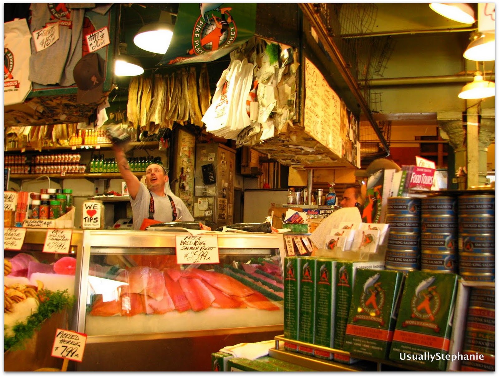
Catching fish at Pike Place Market.
In the morning, we took trips to the post office, where the Transporter sent home some souvenirs:  coffee for her supportive hubs and loot – lots of it – for her tyke, and to the bank.  Then the Transporter and I played tourist.  We took the bus in to Pioneer Square to hit the Klondike Gold Rush National Historic Park (another stamp!), strolled around in Pike Place Market (fish thrower guys), wandered by the original Starbucks, and took the Monorail to Seattle Center and the Space Needle (we did not go up).  After a little confusion, we found the right bus stop and headed back "home".
The original Starbucks storefront.
Bright and early the next morning, it was time for the Transporter to return to Mississippi.  After a few hugs goodbye at SeaTac Airport, she was on her way to her Southwest flight, and headed home. I was about to spend 6 months in Seattle.

Monday, August 23, 2010

Washington to Washington, part 3

(...continued from Part 2)


Day 6.  Cody, WY to Yellowstone National Park.

First things first:  we had breakfast at the Mayor's Inn.
Eggs Benedict at the Mayor's Inn, Cody, WY
Yum.  Then we set out for the Sierra Trading Post Outlet in Cody and gave ourselves a half hour limit.  The co-pilot (we has since told me she wishes to be referred to as the Transporter), being from Mississippi and about 15 weeks pregnant, needed some warm clothes for Yellowstone.  So we emerged with fleece, hats, and gloves.  Within half an hour.  And that included a foray to the skis section (there were only 2 pairs of skis there).

On our way to the park, we stopped at Buffalo Bill Dam and picked up a random stamp.  The dam is touted as the tallest at the time it was built.  Not to be a total PITA, but doesn't it seem like every dam was the widest, largest in volume, tallest or whatever superlative at the time it was constructed?  Just sayin'.

We entered Yellowstone NP through the east entrance and almost immediately encountered bottlenecking due to some bison that were hanging out in a field.  We had decided earlier that driving the entire Figure 8 would be ambitious, so we settled for the lower loop and skipping, among others, Mammoth Hot Springs.  Both the Transporter and I had been to Yellowstone previously.  In fact, it was the impetus for my 6th grade science fair project on geysers.  I [heart] gesyers!  

Anyway, our first stop in the park was Lake Village, on the north end of Yellowstone Lake, for a park stamp.  We made a stop at a geothermal spot, said hello to a bison that was just lying around (I am convinced they all drew straws that morning to see who would have to go out for the tourists), and I ditched the Transporter for a quick jaunt up a hill to see some geysers, passing more bison along the way.  
From there we went north to Canyon Village, for another stamp, and more importantly, lunch.

We continued counterclockwise to Norris, got a little disoriented – which is a little embarrassing because, the drive is, after all, a CIRCLE – and then headed towards Old Faithful, where we had a basic cabin reserved for the night.  The key to exploring Yellowstone by car, by the way, is to just duck into the side roads that may or may not be marked on the map.  They're less crowded than the main loop road, and often you'll be sharing geysers and thermal pools with less than 10 other people.
Hot spot on a side road
We made a quick stop at Madison Lake for a stamp (and begged the ranger to open the store for us to actually stamp our passports).  We also took in the view and chatted ever so briefly with a guy wearing an LSU hat and that the Transporter thought would be perfect for me.  Seriously, this guy looked like he was 21.  And we'd never see him again.

It was time for dinner at the Old Faithful Snow Lodge and then a night in our cabin.  Half the guide books we read said that the cabins were little more than a tent.  I don't know what kind of tent those writers have been staying in, but the cabin was sturdy and reminded me of the private cabins that my friends Elizabeth and Eric stayed in in Patagonia.  I mean, this cabin put to shame the sheet metal with exposed fiberglass hunting-shed-turned-"cabin" that I stayed in at a yoga retreat in West Virginia a year ago.  It's all relative.
Old Faithful Budget Cabin

 Day 7.  Yellowstone NP to Jackson, WY

At breakfast at the Old Faithful Inn Dining Room, we had noted the time of Old Faithful's next eruption and headed behind the geyser to Observation Point.  Let me just say, I don't hang out with many pregnant women.  And when I do, it's not to do physical activities.  Most of my pregnant friends, uh, go home after work.  Observation Point is a well-pitched incline up above Old Faithful and the geyser basin.  It's a more interesting view of Old Faithful than down where the bleachers are on the boardwalk.  The Transporter humored me.  Actually, she was humored because a family came up to the observation area, and she was convinced it was LSU boy's family.  Well, she was half right.  It wasn't his family, but LSU boy did show up.  And looked about 18 years old (he shaved this morning), and this time, the Transporter agreed.
Old Faithful Geyser from Observation Point
Old Faithful was on time, although the steam the geyser emitted sort of blocked our view. Which is just as well because all of my closeup photos from this were rather blurry, so you'll just have to settle for this photo. The trail to Observation Point heads out to Solitary Geyser, which was a treat, and then returns to the boardwalk where the masses gather. The boardwalk is an unfortunate necessity to viewing this particular geyser basin. Because we were doing merely a drive-by, rather than spending a significant amount of time in the park, it made sense for us to wander around with the masses. By the time we circled back, about an hour had passed, and Old Faithful was set to go at any minute. And we got a better view the second time around. Yay!

From Old Faithful, we set out to finish the loop. We had lunch near the Continental Divide and then picked up our last Yellowstone stamp at Grant Village before exiting through the South Exit toward Grand Teton National Park.  We drove down the John D. Rockefeller Memorial Highway that everyone exiting via the South Exit does. We caught our first glimpse of the Tetons as we made our way around Jackson Lake. We stayed west and headed to Jenny Lake, stopping at a viewpoint to walk down to the lake. Amazing, amazing views! We picked up stamps at Colter Bay Visitor Center, Jenny Lake Visitor Center and the fancy schmancy new Craig Thomas Discovery and Visitor Center in Moose Junction (there was also a girl in a prom dress there, but we'll ignore that because my brain can't process that).
Jenny Lake.
Lodging for the night:  the Lexington at Jackson Hole (we definitely paid for location), although its breakfast was pretty good; yummy dinner at Lotus CafĂ©.  We'd been traveling for a week!

(to be continued....)